The dictionary defines a fjord as “a narrow inlet of the sea between cliffs or steep slopes.”
That’s a precise but inadequate collection of words when measured against the real thing on the west coast of Norway. The numerous fjords that turn Norway’s coast into a jagged line are routinely, and rightly, called beautiful, awesome and more.
Rather than conjuring more adjectives, I will interrupt this narrative with a small gallery of my photos collected in those fjords this summer (2023).
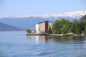
Except for the last one, photos above and below were taken over a period of three days while sailing amid the fjords of Norway. The last photo is a scene on the Sognefjord visible from quayside in the small town of Balestrand.
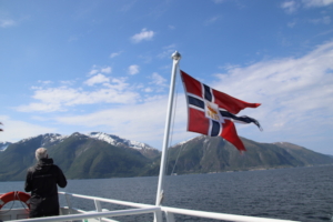
With Jim, my travel companion, I joined a three-day cruise tour into Norway’s fjords, departing from Bergen early on a June morning.
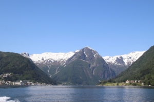
This initial four-hour foray into those narrow inlets took us into the country’s longest (100 miles) and deepest, the Sognefjord, and to a tiny dot on the map, the town of Balestrand (population, 1,300 or so).
We sailed out of Bergen Harbor and through the waters near it, waters that together constitute the Byfjord, a name that simply means Cityfjord.
We traveled aboard a ferry, operated by Norled, which offered plenty of indoor seating, as well as good space to sit or stand on front and back decks to gawk at the scenery, literally for hours. I gawked at the scenery, literally for hours.
I wore a jacket for this, which was good. Although the morning became quite sunny, the wind produced by our relatively quick pace on the water was at times bracing.
Balestrand
We arrived at Balestrand around noon, walked the short and steep route to our hotel where we could quickly drop baggage and shed coats. It was a lot warmer on land under the sun with no wind.
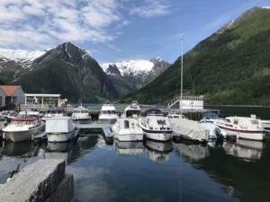
Coming into the quay, which is to the left, on arrival at Balestrand.
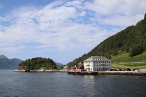
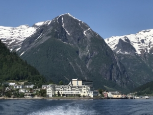
We were staying at the 190-room Kviknes Hotel, a charming wooden resort built, in 1913, in what is called the Swiss style (and without elevators). There is a newer addition (with elevators), but I don’t know when that was built. The hotel business itself has been operated by the same family since 1877.
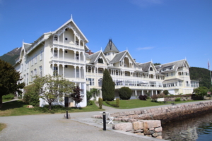
The 1913 wing of the Kviknes Hotel.
Jim and I couldn’t check in until 3 p.m. so we dropped by a tiny grocery to buy anything picnic-y, then munched those snacks while sitting in one of the prettiest places ever. Although the bulk of Balestrand faces the Sognefjord, we stumbled onto the part that does not: We found benches facing a tiny arm of the Sognefjord, the Esefjord, with snowcapped mountains for a backdrop.
On the Esefjord, site of our lunch.
During lunch, a small bird dive-bombed Jim’s sandwich and may have gotten a piece of it, then a seabird appeared ready to do the same. I got a few really nice photos at the lunch site but sadly nothing of this excitement.
We still had time to kill so we set out along Balestrand’s main street seeing, most impressively, the 19th century St. Olaf’s stave church. Because it is still an active church and not so old, its exterior is painted with a yellowish trim. Any other stave churches I have seen were older (a LOT older), darker and unpainted.
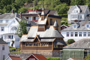
The 19th century St. Olaf’s stave church in Balestrand.
We stopped at two Viking burial mounds, the taller one said to hide the grave of a legendary King Bele, a figure from the saga of Fritjof the warrior. The cone-shaped mounds are definitely unnatural and intriguing — and easy to climb.
Along the way, we found a few of the town’s villas erected by local artists between 1890 and 1900, and notable for several reasons. They are tall, rather intricate affairs painted red and featuring lots of balconies, tiered roof levels and rooftop elements using a dragon motif. (The dragonheads are a symbol taken from Nordic sagas.) Most interesting to me: Many were prefabricated buildings shipped to Balestrand in pieces.
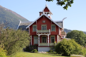
One of several villas erected in Balestrand in the late 19th century and notable for their red color and the dragon motifs in roof trimmings.
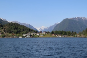
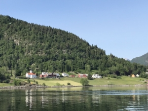
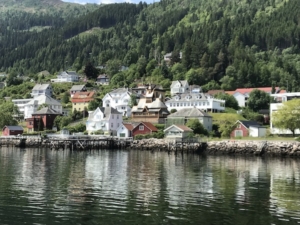
The town, under glorious sun, was pretty and photogenic, which I acted on often.
Above, houses on the main drag in Balestrand. Below, the town of Balestrand, stretched out along the Sognefjord shoreline.
Back at the Kviknes Hotel, I looked for the Hoyvik Room in the property’s 1913 building. The hotel has a collection of artwork and antiques, but the Hoyvik Room stands out because it is filled with some very unusual examples of hand-carved wooden furnishings, made by local craftsman Ivar Hoyvik.
It turns out that the last German Kaiser (Wilhelm II) stayed at Kviknes Hotel frequently and was on site in 1914 when he learned that Austria had declared war on Serbia; that event would drag Germany into the brawl that became World War I. The specific hand-carved chair where he sat is still in this room.
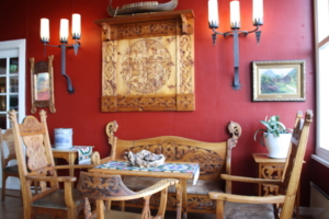
The Hoyvik Room with examples of furnishings carved by local craftsman Ivar Hoyvik, in the Kviknes Hotel.
Our cruise tour included buffet dinners (lots of food) in a large dining hall, also in the older of Kviknes’ two buildings. Out of curiosity, I asked front desk personnel about restaurants in town, and they mentioned only two. I had seen them; they looked to be in private residences or former residences.
The Jostedalsbreen glacier
The Norwegian Glacier Museum and the Jostedalsbreen, the largest glacier in Continental Europe, formed the centerpiece of our second day in the fjords.
This involved a sailing (about 75 minutes) from Balestrand into the Fjaerlandsfjord to the town of Fjaerland.
The steep and sometimes snowcapped mountains, tiny farms, small towns and striking red houses along the shoreline combined with clear blue water and skies made for gorgeous scenery (all this was true the day before and the day after, too).
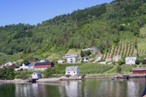
Of necessity, farm fields sit very close to fjord waters.
Arrival site in Fjaerland. The figure seen “working” at the side of the closest building is a dummy. A joke perhaps?
We went first to the museum, which is a small interactive facility built in 1991 and meant to resemble a boulder. It does, to a degree.
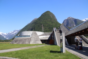
The Norwegian Glacier Museum, designed to look like a boulder.
Here, we first watched a dramatic 15-minute film (made using drones) meant to convey what this huge glacier looks like from all angles and how it can be and is used, by a few, for climbing and cross-country skiing plus kayaking in the associated waters. The film was presented entirely without narration (good for all international visitors) and on a 3-year-old panoramic screen, which is the largest in Europe.
Exhibits included some interactive elements (in one instance, graphically demonstrating how hard the glacier’s ice really is) and other sections on the creation of a glacier, the extinction of mammoths and what is known of the “Iceman” who was found in Switzerland some years ago.
Signage provided these stats about the Jostedalsbreen. The glacier covers 183 square miles, is 37 miles long, is 6,420 feet high at its highest elevation and is 1,873 feet deep at its thickest point. Its volume is 17.5 cubic miles, equal to 300 billion bathtubs full of water or the total water consumption in Norway for 100 years. It causes the erosion of 400,000 tons of rock material per year.
That is one big ice cube.
Traveling by motorcoach, we went to a vantage point for the Boyabreen wing of the Jostedalsbreen glacier, in the Jostedalsbreen National Park. We were below the ice, standing near a lake produced by the glacier’s runoff. It was impressive to note how much cooler it felt to stand near the runoff, as compared with our estimated 80-degree weather that day.

A tiny part of the Boyabreen section of the Jostedalsbreen, the largest glacier in Continental Europe.
Not to cast aspersions on the glacier’s outsized characteristics, but this way of seeing a glacier seemed anti-climatic compared with Alaska glaciers and the Moreno in Argentina. I realize it is easier to get good vantage points for viewing the other glaciers and even to watch them calving.
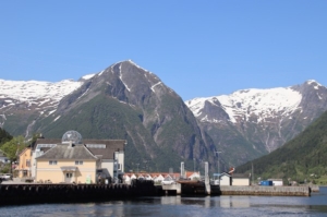
The next day, we were on the ferry again, for a continuation of the trip we took from Bergen to Balestrand. We were heading farther east on the broad Sognefjord and then a bit south to Flam.
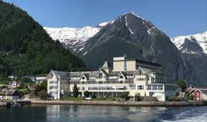
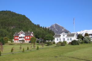
Above and below, the Kviknes Hotel recedes as we sail away, revealing just how dramatic the setting is for the property and for the town of Balestrand.
This ride, under perfect skies, lasted one and a half hours and was, for me, more enjoyable than the ferry ride two days previously, partly because I was warmer and maybe because the sky was perfect the whole time. Oh, and I was less jetlagged.
Flam Railway
We left the Sognefjord to enter Aurlandsfjord. Flam, our destination, was at the end of that fjord, but the Flam we saw is a tourist hub, nothing more. The real living town is about 20 minutes away on foot.
The tourist site receives ferries like ours and huge cruise ships. A big ship, accommodating 6,300, was at the dock when we arrived. So, there were scads of people wandering around, getting food and shopping in numerous outlet stores!
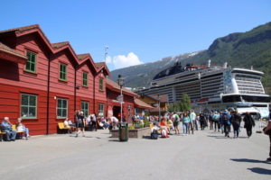
The tourist hub at Flam, with shops to the left and a cruise ship that can accommodate 6,300.
With 90 minutes on the ground, we decided to check our bags. What a bad deal that was — $12 per bag.
The reason for this tourist hub is the Flam Railway, which takes riders up or down a steep mountainside offering dramatic overviews of houses and farms in the valley below, a view of an amazing switchback road and even a stop to see a waterfall, where vast amounts of water gushed noisily down the mountain.
On the railway, we traveled up, moving from sea level to 2,841 feet above that, all in a 12.4-mile trip.
In the midst of this ride, the train — which accommodates about 500 — stopped and passengers were invited to disembark and view the Kjosfossen waterfall from a platform, at which point the music started. First we heard the pleasantly eerie music, then we spotted a performer, in a red dress, moving to the music high up in the rocks to the right side of the falls.
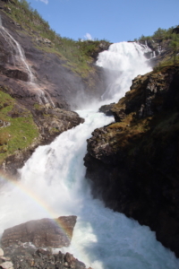
The Kjosfossen waterfall, seen and heard at close range. The rushing waters made a lot of noise, competing with manmade music.
After we reboarded, the train traveled through a horseshoe tunnel that turns 180 degrees inside the mountain. We could still see views down into the Flam Valley through openings on one side of the tunnel.
At the top of this climb (about 45 to 50 minutes after leaving Flam), we came to the Myrdal station. Here, there is a small “station village,” no real town.
But there was a bit of entertainment though: There was a construction site high up on the adjacent mountainside, and we watched as project components were delivered by helicopter.
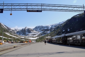
The Myrdal railroad platform at 2,841 feet above sea level. Don’t be fooled by the snow on the mountains in the background. In mid-June, it was warm on that platform.
We were meant to wait an hour, then board a high-speed train to Oslo. And with that, this blog should end, but there was this:
While Canadian forest fires were affecting states across the U.S., there were Norwegian forest fires — fires that damaged the signal system for some rail services. Signals had to be repaired so we were delayed four and a half hours.
At the same time, we learned later, service between Myrdal and Bergen was also interrupted, but that was due to buckled tracks, buckled because of heat. Norway was having a very hot day.
For more information about Norway, we offer at BestTripChoices.com the following, under the headline, Nobel country, https://besttripchoices.com/norway/
This blog and its photos are by Nadine Godwin, BestTripChoices.com editorial director and contributor to the trade newspaper, Travel Weekly. She also is the author of “Travia: The Ultimate Book of Travel Trivia.”